


Bret Fenster, GISP County of Collin, Texas The Art of Presidential Primary Patterns Traditionally, polling locations have been assigned to voters near their precinct, and they have not had the option to vote in other locations throughout the county. Since 2009, “vote centers” have allowed citizens in Collin County the freedom to cast their ballot where it is most convenient for them. In this map, early voting turnout from the 2020 presidential primary election is shown. Voter distribution is represented with lines going from the voter’s address to the selected vote center where they cast their ballot. Given the option, it appears that people will vote in locations that are not always close to home. This helps election officials project how busy and popular each voting center may be in the future. Popular vote centers will receive more equipment and staffing to meet the projected demand. Experimental symbology yielded an artistic interpretation of the data on a watercolor basemap. The exported map was enhanced to add an oil painting effect for additional texture. It intentionally contains no labels to reinforce the vision of “data as art”.
| Bret Fenster, GISP County of Collin, Texas Ross Cemetery Survey Collin County’s Historical Commission sent me a request: “Bret, We are thinking about mapping Ross Cemetery which is on Hwy 5 to the south of Pecan Grove. Do you know of any mapping programs that could be used?” Well, I did. Rather, I had some ideas… 1. Make them a paper map and let them draw things on it. 2. Set up an editing layer in ArcGIS Online and let them draw things on it. 3. Create a grid to manage the collection of data and let them draw things on it. 4. Use LiDAR to find graves like Mayan ruins in a Guatemalan jungle. 5. See if ArcGIS Earth would work because it’s free. None of these ideas used an application which captured location and/or pictures. Then, the “AHA” moment – Isn’t there some ESRI app that could collect this data? Oh yeah, ArcGIS Field Maps! Let’s see what we can do with our smartphones, crouching around tombstones. Sounds fun to me!"
| Candace Johnston-Perry and Daniela Spade OU Center for Spatial Analysis Transitioning Pest Data Collection from Excel to Field Map ODAFF collects field data checking for pests such as the imported fire ant, Japanese beetle, sweet potato weevil, and carnal bunt. Prior to CSA’s contract with ODAFF, ODAFF was using excel spreadsheets to track trap locations and status. This poster summarizes CSA’s workflow to create a user friendly way for ODAFF field workers to accurately and consistently collect field data using Field Maps.
|
*2nd Place Winner of Map Gallery Contest* Daniela Spade and Candace Johnston-Perry OU Center for Spatial Analysis The Center for Spatial Analysis: Key Projects and Services The Center for Spatial Analysis provides geospatial consulting services to government agencies, private industry and the University of Oklahoma, in addition to academic research and educational outreach. This poster provides an overview of CSA's major projects and areas of expertise.
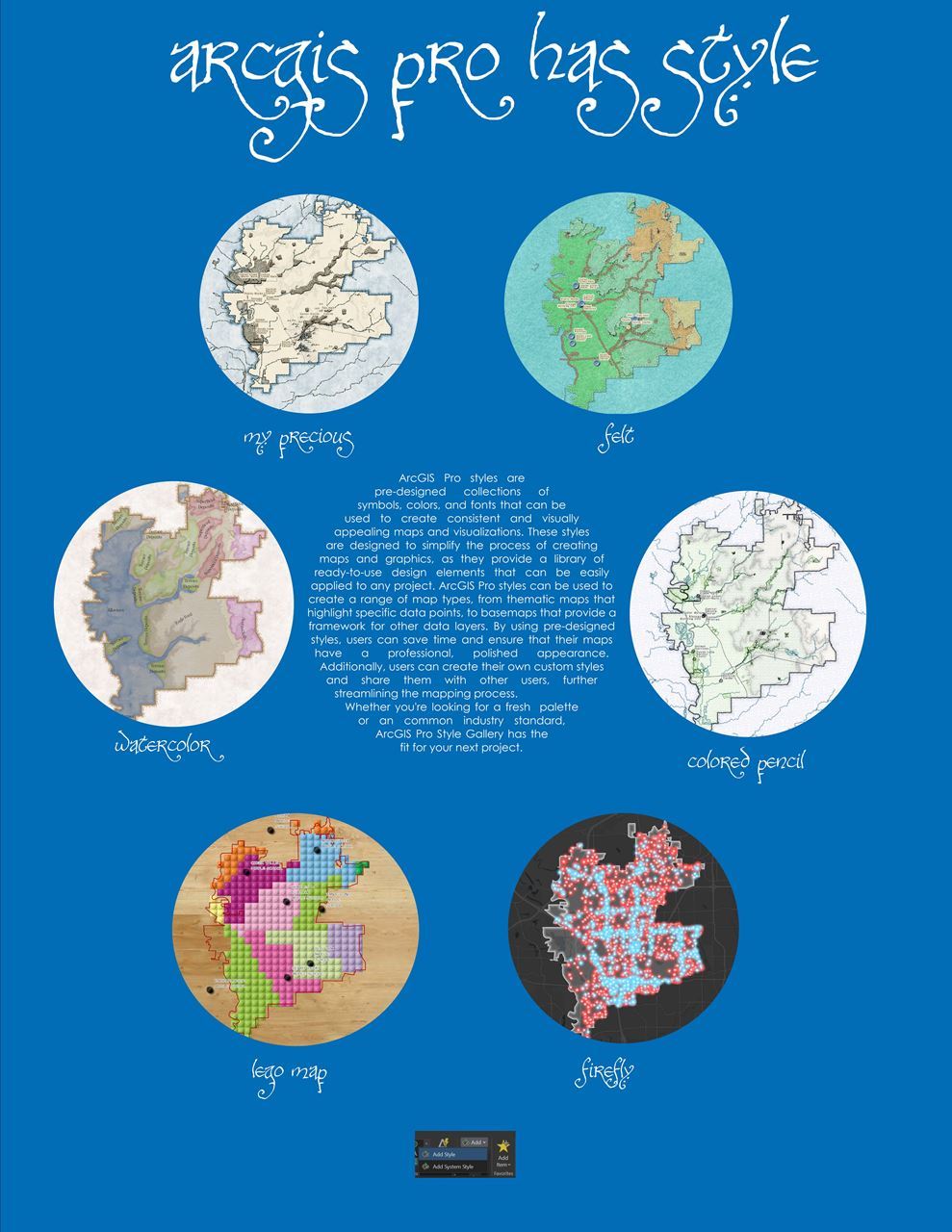
| Garri Grossi City of Carrollton ArcGIS Pro Style Collection ArcGIS Pro is just as powerful a tool and even has some added functionality that you can't find in ArcMap. For example, Pro Styles turn Drab into Fab when applied to any project. Submitted for your approval are the same basemaps with various styles applied.
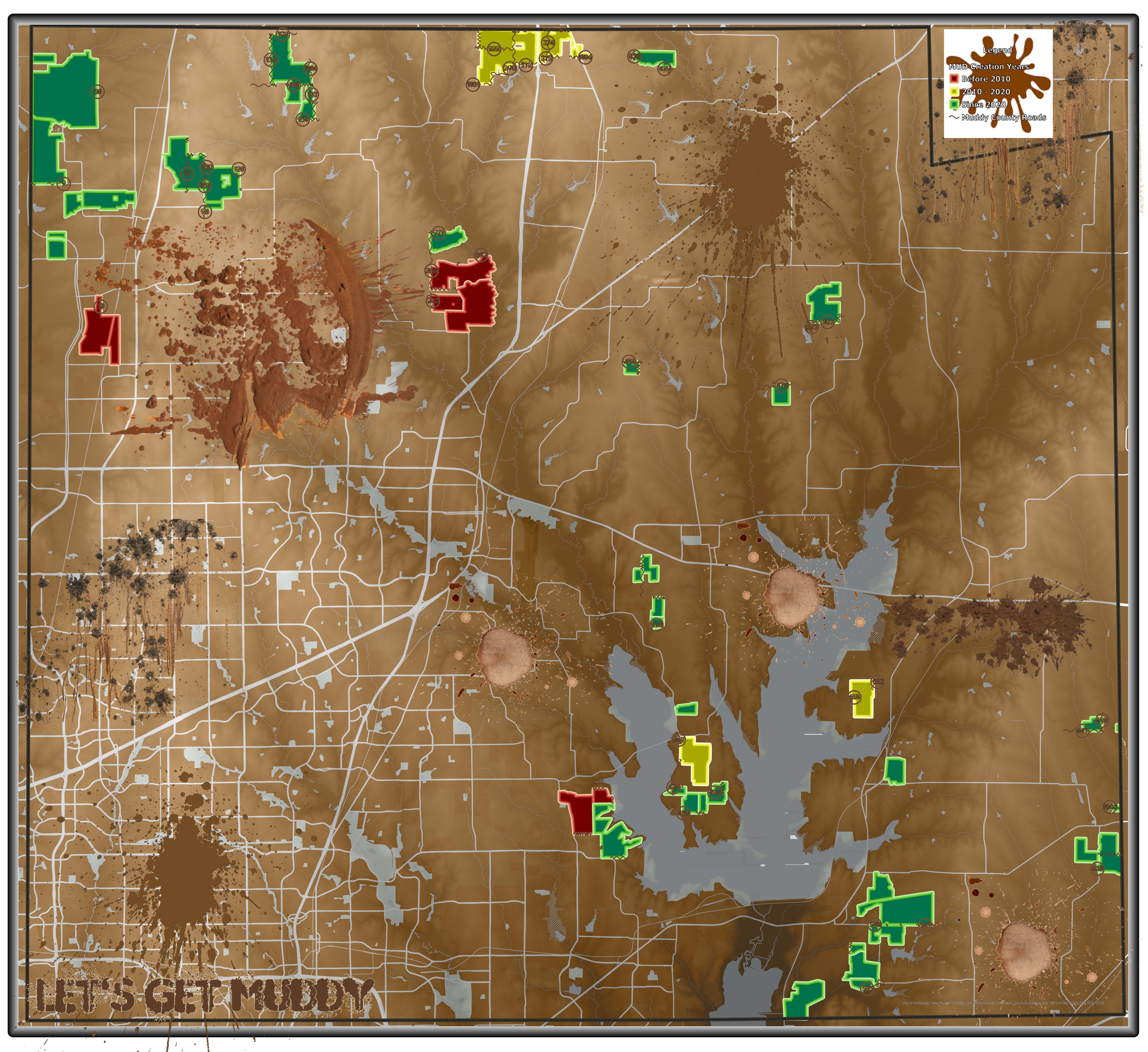
| Kendall Holland Collin County Let’s get MUDdy! The Texas Legislature created the first special districts in the 1890s for navigation and irrigation. In the 1920s and 1930s, river authorities were created for water supply and electricity projects. Collin County has had a few special districts over the years, but not a lot of MUDs. MUDs are municipal utility districts, but for the purpose of this map, we are including other special districts. This includes one SUD (special utility district), a couple of MMDs (municipal management districts), and even a WCID (water control and improvement district – a wicked as GIS calls them!) Together these make up our layer named MUD. GIS named it as such before it was realized just how muddy special districts were going to become! The purpose of this map is to depict the explosive growth of MUDs the last couple of years. The Collin County Administrator asked GIS to produce a quick study to identify the intersections of MUDs and county roads and to give an estimate of the ultimate buildout population within each MUD. The daily traffic of large trucks and construction enterprises rapidly degrades the existing asphalt roads. In turn, this could lead to the need for a bond election to fund the repair of these roads or to replace them with concrete roads. The estimates on population growth can also be used to assess emergency services and traffic congestion.
|
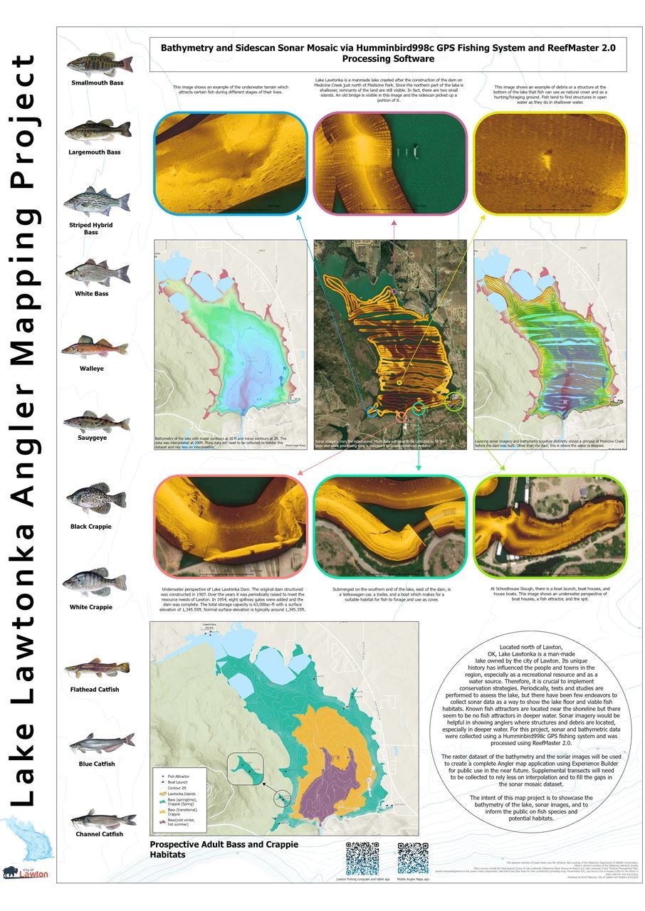
*3rd Place Winner of Map Gallery Contest* Kristi Shannon City of Lawton GIS Division Lake Lawtonka Angler Mapping Project Located north of Lawton, OK, Lake Lawtonka is a man-made lake owned by the city of Lawton. Its unique history has influenced the people and towns in the region, especially as a recreational resource and as a water source. Therefore, it is crucial to implement conservation strategies. Periodically, tests and studies are performed to assess the lake, but there have been few endeavors to collect sonar data as a way to show the lake floor and viable fish habitats. Although SCUBA diving can be a useful survey method of fish habitats, the visibility level in Lake Lawtonka is poor, and this method would be time intensive for mapping purposes. Sonar and bathymetric data were collected using a Humminbird998c fish finder and was generated using ReefMaster 2.0. The raster dataset of the bathemetry and the sonar images will be used to create a complete Angler map application using Experience Builder for public use in the future. In the future, supplemental transects over the lake will be needed to collect more data and improve the dataset. For now, the intent of this map project is to showcase the bathymetry of the lake, sonar images, and to inform the public on fish species and potential habitats.
| Nicole Dogan, GISP TOWN OF FLOWER MOUND Genealogical Research, Enhanced with GIS A view of one families journey from Europe to Australia and beyond. Harnessing GIS to bring meaning to flat files. Combining GIS data, creating maps and charts and utilizing Esri tools to explore genealogical data.
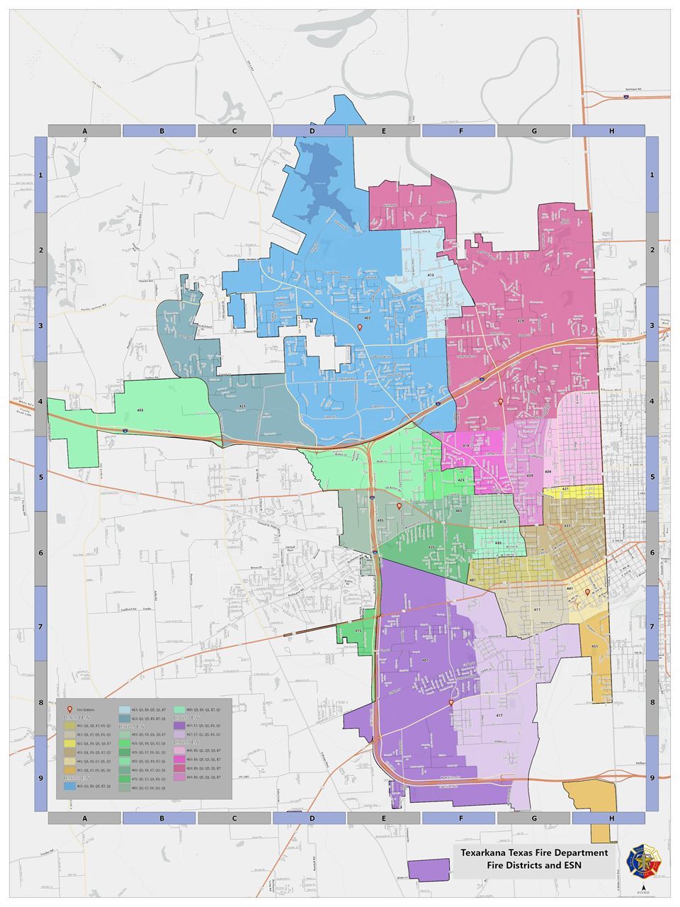
| Terri Rogers, GISP Texarkana Water Utilities Texarkana Texas Fire Department - Fire Districts and ESN Map showing the fire districts of Texarkana Texas. It also shows the ESN which is the emergency service number. It tells the 9-1-1 dispatcher which fire protection service to send to any given address within Texarkana TX. It also shows a street index grid.
|

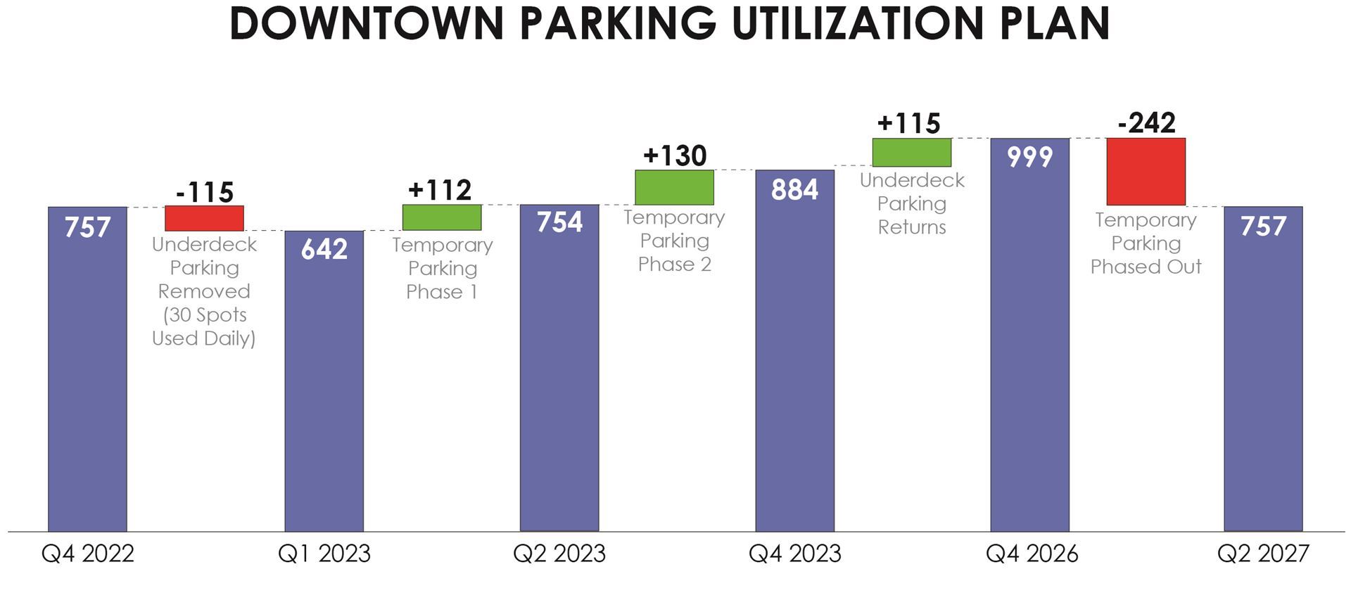
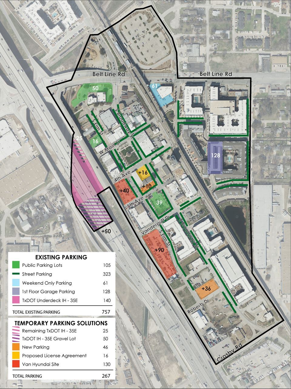
Emily Offer City Of Carrollton Downtown Parking Utilization The Downtown Parking Utilization project aims to address the sudden closure of the underdeck parking lot by TxDOT in December 2022. Despite being told by TxDOT that the closure would be phased, the entire lot was closed, leaving the City of Carrollton to find viable solutions to mitigate a lack in parking availability. The downtown Carrollton area is also a TOD area and hosts a station for DART's Green Line. It is of utmost importance to Carrollton to ensure the business and commerce of the downtown Carrollton area, that is currently supported by 757 parking spots, is not negatively impacted by the underdeck parking closure. Proposed Phasing Timeline:
140 underdeck parking spots are to be closed off to the public and 25 parking spots are to remain available until TXDOT completes construction on IH-35E.
Downtown Carrollton currently benefits from free parking via 16 spots adjacent to the Plaza Theater provided by Pablo Mena. This parking area will need a license agreement in the near future to ensure the permitted usage continues. The city owns a lot south of Plaza Theater, this lot will be converted to host 10 parking spots. Construction of a temporary parking lot at 1440 S Broadway will be complete and is to include approx. 36 parking spots as well as improvements to existing public parking via striping and additional signage. TXDOT intends to provide a gravel lot including 50 parking spots south of the underdeck parking closure.
Van Hyundai anticipates completion of their new facility. Staff has asked they seriously consider expediting relocation efforts and release as many parking spaces as possible. Approx. 130 spots within two surface parking lots for public use will be made available at the time of their move.
TxDOT's construction is meant to be complete, 140 underdeck parking spots would be made available to the public again. The City would close approx. 130 parking spots located on the former Van Hyundai properties and sell the properties via a Request for Proposal (RFP).
All temporary parking solutions are to be phased out.
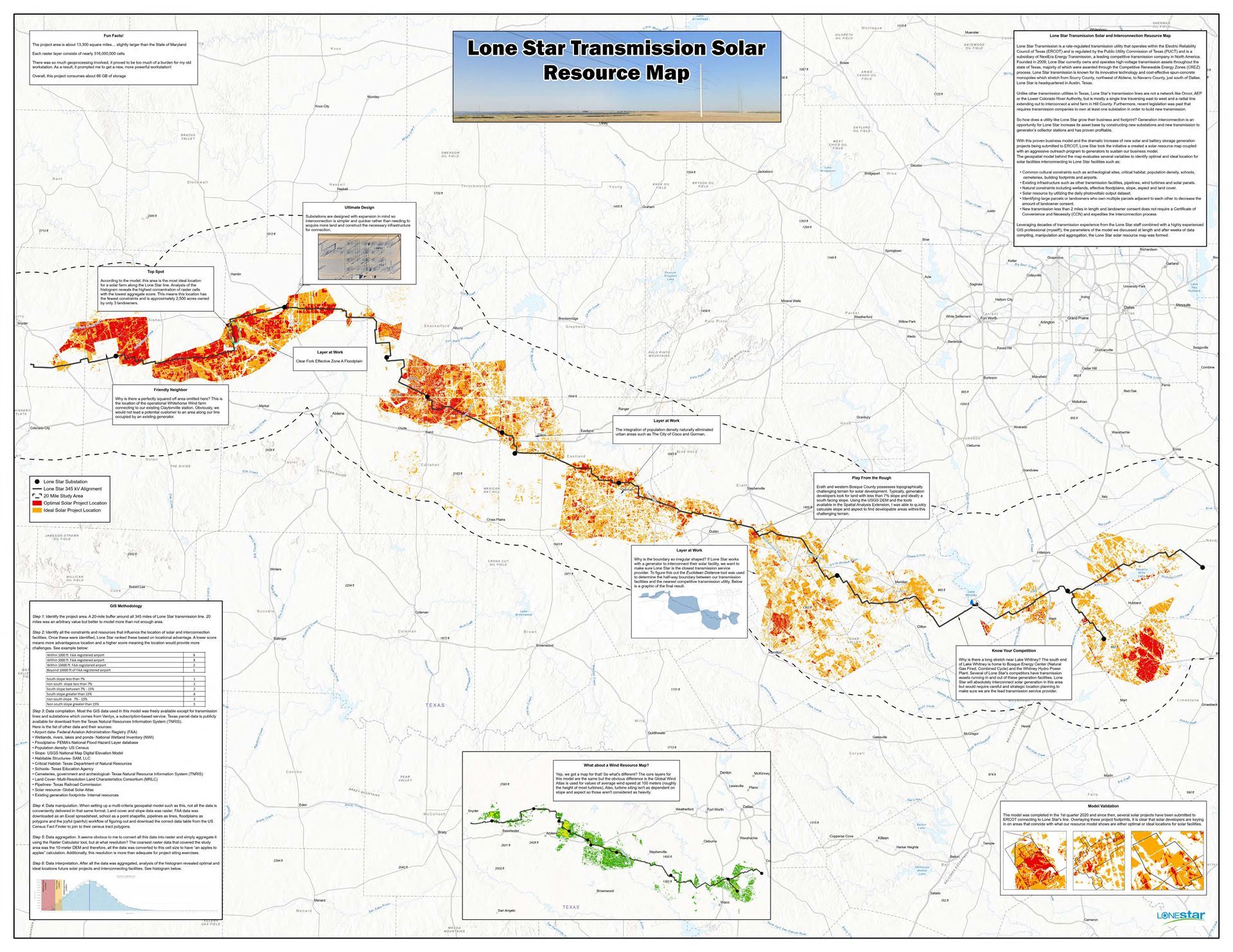
| *1st Place Winner of Map Gallery Contest* Joe Gilberg Lone Star Transmission, LLC Lone Star Transmission Solar Resource Map With the strong push for grid decarbonization as well as the recent passing of the Inflation Reduction Act (IRA), there is more importance than ever to interconnect renewable energy such as solar to existing transmission lines. Not only is this environmentally beneficial, but a great opportunity for transmission service providers such as Lone Star to increase revenue and their asset base. The solar resource map surrounding the Lone Star transmission line in north central Texas takes the guess work out for potential generators to locate new facilities and increase their rate of success interconnecting their facilities into the ERCOT grid.
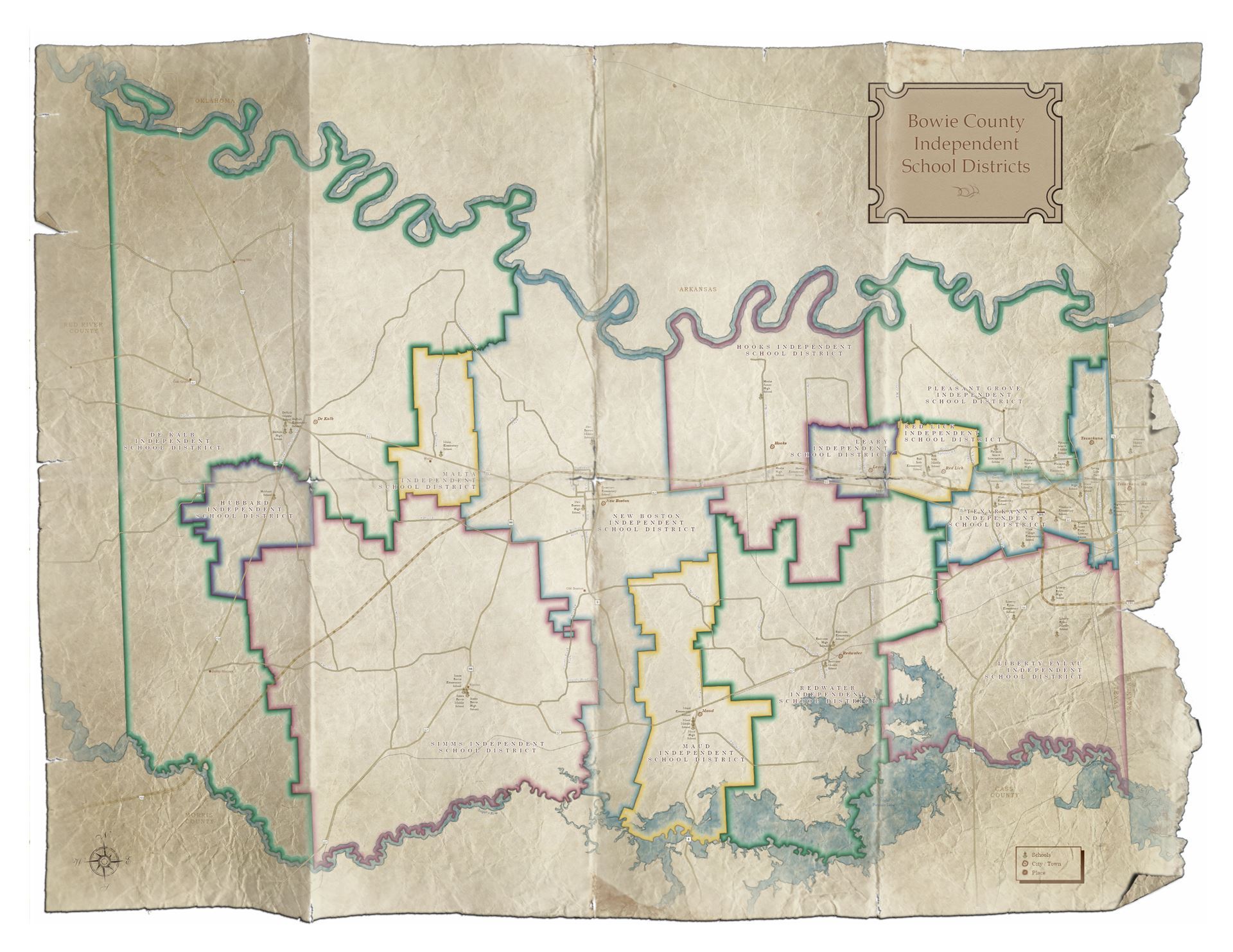
| Terri Rogers, GISP Texarkana Water Utilities Bowie County School Districts Map showing the Bowie County Independent School Districts of Texas. Bowie County has 13 different Independent School Districts. Bowie County is in the far northeastern corner of the state, bordered by the Red River on the north, with Arkansas and Oklahoma across its northern boundary and Arkansas to the east. The county is named for James Bowie, the legendary knife fighter who died at the Battle of the Alamo. It was established in December 1840. This map was created using various antique styles and colors. No basemap was used in the creation of this map. I wanted the look of an old-time parchment map that has been stuffed in some desk drawer forever. I wanted it to look from the 1840’s.
|
Laura Smith
Clara Luper & The NAACP Youth Council - A City Changed Clara Luper & the NAACP Youth Council led a series of sit-ins across Oklahoma City that would last six years and change the nation. However, the revitalization projects that took place in the Downtown district of Oklahoma City would demolish most of these locations, leaving the footprint of their efforts obscured. This research project attempts to turn back time and record the movements of the sit-inners and their impact on Oklahoma City.
|

Contact SCAUG at : Webmaster@scaug.org | South Central Arc Users Group P.O. Box 96 Ardmore, OK 73402 |
