** Conference Registration is Required to Attend Workshops and Training

Monday, September 25, 2023
Workshops
Morning Workshops
Monday, September 25 - 8 am to 12 pm
Transitioning to ArcGIS Pro
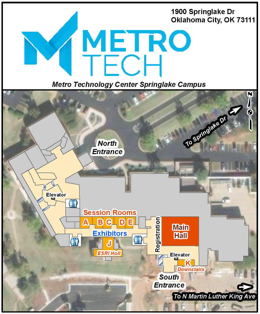
Classroom A
$150
Instructor: Esri
Users will need to bring their own laptops with ArcGIS Pro installed.
Are you still an ArcMap user? Come learn about strategies to prepare for your move to ArcGIS Pro, identify and prioritize the migration of key workflows, and spend some time exploring the ArcGIS Pro interface. Take the apprehension out of transitioning from ArcMap to ArcGIS Pro, gain the skills you need, and learn where to find your favorite tools. Learn different tips and tricks, as well as strategies to tackle essential workflows such as editing, querying, basic analysis, and sharing with ArcGIS Pro.
Hands-on exercises will give you the experience needed to efficiently work with ArcGIS Pro.Introduction to ArcGIS Drone2Map
Classroom B
$150
Instructor: Esri
Users will need to bring their own laptops with ArcGIS Pro and Drone2Map installed.
Drone2Map for ArcGIS is a desktop app that turns raw still imagery from drones into orthomosaics, 3D meshes, tile images, and more, in ArcGIS. Now, with drone hardware becoming more accessible, you can create 2D and 3D maps of hard-to-access features and areas.
Use these professional quality imagery products to monitor environmental change and to perform land analysis and critical infrastructure inspection. Together with many other capabilities in ArcGIS, Drone2Map helps you unlock the insights hidden in your imagery. As drones continue to revolutionize how we work today, Esri can help your organization gain the benefits of this emerging technology.Introduction to SQL for Enterprise Databases
Classroom C
$150
Instructor: John May
Laptop Not Required
All That and a Bag of Chips! Invisible Skills That Get You Noticed
Classroom K
$150
Instructors: Madeline Dillner, Tim Nolan, and Friends
Laptop Not Required
When it comes to thriving in a professional environmental, having stellar GIS skills will only take you so far. This workshop in four parts will give you an overview of the invisible professional skills that are rarely taught, often expected, and always appreciated — such as organization, a growth mindset, excellent communication, and integrity. Not only will these skills help you move forward in your career, they can help you become someone people are eager to work with. Master these invisible skills – and you’ll be much better prepared to take on leadership roles in your organization and beyond. If you combine them with the GIS skills you’ll pick up at the rest of the conference, you’ll be all that… and a bag of chips.
8:00 - 8:10 AM - Introduction & Class Overview - Madeline Dillner
8:10 – 8:50 AM – Tools of the Trade: Staying Organized and Getting Stuff Done - Tim Nolan
- Personal Kanban
- Pomodoro
- MITs
9:00 – 9:50 AM – Ripples from a Growth Mindset - Madeline Dillner & Tim Nolan
- Self-Awareness, Self-Confidence, Self-Love
- Recovering from Perfectionism
- Vulnerability & Empathy
- Adaptability
10:00 – 10:50 AM – Communicating Forward - Tim Nolan
- Active Listening
- Communicating
- Conflict Resolution
- Collaboration
10:50 – 11:00 AM – BREAK
11:00 – 12:00 PM – Integrity/Lessons from Leadership – panel discussionAirborne Lidar: From Project Plan through Final Delivery
Classroom E
$150
Instructor: Surdex
Laptop Suggested but Not Required
LiDAR data and its derivatives can be incredibly helpful for all ranges of applications, but the quality of data can limit its effectiveness. With proper understanding of best practices, including standards and specifications, project planning, acquisition, processing, QA/QC, and final derivative creation, you can ensure your data will give you the most bang for your buck. In this workshop we will go over many of these best practices as well some demonstrations within typical software packages to get you started towards your next successful project.
Field and Office Techniques for Seamlessly Integrating GPS Data with GIS
Classroom D
$150
Instructor: AllTerra
In this workshop, we will look at techniques and software that will aid in a seamless transition between your GIS and the field. In the ArcMap plugin for TerraFlex, we will cover how to create field templates to match your geodatabase, how to push out work-order updates, cache background maps, and best practices in the field with GPS.
Laptop Required
Afternoon Workshops
Monday, September 25 - 1 pm to 5 pm
What’s New in ArcGIS Pro 3.0 & Beyond
Classroom A
$150
Instructor: Esri
Users will need to bring their own laptops with ArcGIS Pro installed.
ArcGIS Pro 3.0 is known as a breaking change release so whether you are just getting started with ArcGIS Pro or have used it for years, there is new stuff to learn and take advantage of!
Still using ArcGIS Pro 2.x? Learn how to migrate from ArcGIS Pro 2.x to 3.x. Along the way you’ll learn crafty tips and wily tricks to boost productivity and efficiency when completing your work in ArcGIS Pro.Areas covered will include:
- · Productivity and performance
- · Help and learning resources
- · Application management settings
- · Mapping and visualization
- · Data management and editing
- · Analysis and geoprocessing
The All-in-One App for Fieldwork ArcGIS Field Maps
Classroom B
$150
Instructor: Esri
Users will need to bring their own laptops with access to the internet and Chrome installed.
Learn more about the ArcGIS Field Maps, the only app your mobile workforce needs to complete their map-centric workflows. Field workers will be able to collect data, mark up maps, capture location tracks, complete assignments, and navigate to assets all from one app. This saves time for the field worker because they will only have to download, sign in to, and work with one app – and it saves time for you, because you will only have to configure maps for one application. In this session, you will learn how to configure maps to support your field workflows, create your maps for offline use, and collect data in the field. Utilizing your own mobile device, you will test and deploy your map so it's ready for your mobile workers.
Advanced SQL for Enterprise Databases
Classroom C
$150
Instructor: John May
Laptop Not Required
This course is designed to introduce you to some useful advanced SQL topics and concepts as it pertains
to an ESRI Enterprise environment. Did you know you can create shapes on the fly using SQl, that you can
extract coordinates from shapes using SQL, or that you can perform geoprocessing in the database using SQL?
These advanced SQL topics will enable you to get more out of your database than just the map.
Terrestrial LiDAR Scanning for Indoor Application
Classroom D
$150
Instructor: AllTerra
Laptop Required
In this workshop on terrestrial LiDAR, we will primarily scan an indoor
portion of the conference facility and a small outdoor section. We will
highlight the capabilities and deliverables possible with a terrestrial
scanner and best practices for scanning and processing. Additionally, we
will cover the basics of LiDAR and what tools are available.
All That and a Bag of Chips! Invisible Skills That Get You Noticed
Classroom K
$150
Instructors: Madeline Dillner, Tim Nolan, and Friends
Laptop Not Required
When it comes to thriving in a professional environmental, having stellar GIS skills will only take you so far. This workshop in four parts will give you an overview of the invisible professional skills that are rarely taught, often expected, and always appreciated — such as organization, a growth mindset, excellent communication, and integrity. Not only will these skills help you move forward in your career, they can help you become someone people are eager to work with. Master these invisible skills – and you’ll be much better prepared to take on leadership roles in your organization and beyond. If you combine them with the GIS skills you’ll pick up at the rest of the conference, you’ll be all that… and a bag of chips.
1:00 - 1:10 PM - Introduction & Class Overview - Madeline Dillner
1:10 – 1:50 PM – Tools of the Trade: Staying Organized and Getting Stuff Done - Tim Nolan
- Personal Kanban
- Pomodoro
- MITs
2:00 – 2:50 PM – Ripples from a Growth Mindset - Madeline Dillner & Tim Nolan
- Self-Awareness, Self-Confidence, Self-Love
- Recovering from Perfectionism
- Vulnerability & Empathy
- Adaptability
3:00 – 3:50 PM – Communicating Forward - Tim Nolan
- Active Listening
- Communicating
- Conflict Resolution
- Collaboration
3:50 – 4:00 AM – BREAK
4:00 – 5:00 PM – Integrity/Lessons from Leadership – panel discussion

